| |
|
Geo-IK-2 No. 11 lost at launch The Geo-IK-2 satellite was designed to serve as a precise reference point needed for accurate measurements of the Earth's shape and the properties of its gravitational field. The information can help in the development of highly accurate geodetic coordinate systems for potential military and civilian applications, such as cartography and missile guidance. In the civilian sector, the spacecraft's data can be applied to the study of tectonic plate movements, monitoring of ocean tides, ice conditions and the Earth's rotational velocity. (455) At the same time, accurate knowledge of gravitational field properties along the flight route of ballistic missiles can help increase accuracy of their warheads. (99)
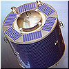
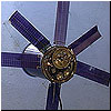
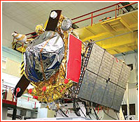
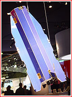
Geo-IK-2 No. 11L (Musson-2; 14F31) satellite in deployed position in orbit. Credit: ISS Reshetnev
Geo-IK-2 No. 11 mission at a glance:
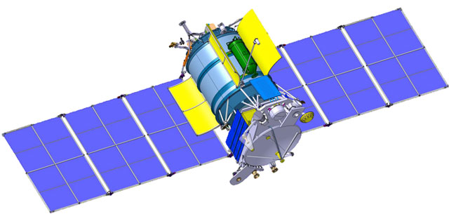
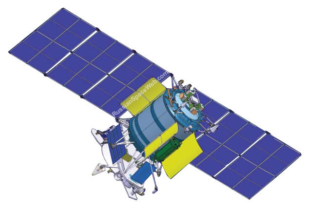
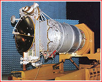
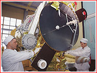
Third-generation system: Geo-IK-2 In 1982, NPO PM started development of a third-generation geodetic satellite system designated Geo-IK-2. A proposed 4.5-ton satellite was based on the Estapheta spacecraft bus and was built around a cylindrical pressurized compartment, which had a height of five meters and a diameter of two meters. The proposed satellite sported a boron-aluminum payload-carrying platform, movable solar panels, gas-to-liquid radiators. A gyroscope-based attitude control system enabled the satellite to point the antenna of its radio altimeter along a local vertical with an accuracy of 15 arc minutes. A triple flashlight system onboard was designed for accurate tracking of the satellite from the ground. A three-boom antenna had a span of five meters. NPO PM planned to delegate the production of the satellite to the Krasmash plant in Krasnoyarsk. Launches of the satellite were expected to start in 1994-1995 onboard the Zenit rocket, probably lifting off from a new launch pad in Plesetsk. All these plans collapsed with the disintegration of USSR. The production of the Zenit rocket was left in newly independent republic of Ukraine and the rocket's launch pad in Plesetsk had never been completed and was eventually re-purposed for the Angara rocket. By the mid-1990s, the Russian Space Forces, VKS, ordered NPO PM to redesign Geo-IK-2 into a smaller, cheaper spacecraft, which could be launched by the Russian-built Soyuz-2 rocket. However in 1997, the Russian government had to essentially stop funding of the Geo-IK-2 project. NPO PM did use a second revision of the Geo-IK-2 design as a basis for the development of the GLONASS-M navigation satellite. Rebirth With the gradual improvement of the Russian economy, the Geo-IK-2 project was jump-started in 2001. The satellite was re-tailored for the light-weight Rockot booster. The diameter of the pressurized container was reduced to 1.3 meters and the mass of the satellite brought down to 900 kilograms. (457) The spacecraft featured movable thermal-control shutters, honeycomb radiator panels and a payload platform carrying the main antenna assembly. The onboard solar panels would be in fixed position during flight. ISS Reshetnev borrowed many of the systems onboard Geo-IK-2 from its GLONASS-M satellite, including the power supply system and propulsion thrusters. Some components of the attitude control and flight control systems were taken from the SESAT, Ekspress-AM and Lutch-4 satellites. The new Russian geodetic network was expected to include two satellites -- Geo-IK-2 No. 11 and Geo-IK-2 No. 12, designed for geodesic measurements with the help of radio and laser-based systems. The satellites were designed to operate in circular orbits 1,000 kilometers above the Earth surface with an inclination of 99.4 degrees toward the Equator. The main instrument onboard Geo-IK No. 11 is the Sadko altimeter developed by France-based Thales Alenia Space. The device was adapted from the Poseidon-2 altimeter, which was installed on the French Jason-1 satellite launched in December 2006. Geo-IK-2 also carries a Doppler system, a time synchronizer, laser reflectors and a range finder. The satellite also carries a sophisticated two-mode receiving and transmitting antenna developed at NPO PM. It was designed to maintain its geometric shape under extreme conditions of space and, reportedly, is capable of operating in Ka-band. The second satellite in the network -- Geo-IK-2 No. 12 -- was expected to carry a Miram microwave radio altimeter, which has been developed by a Russian company, RNII KP. The instrument promised to further improve the accuracy of geodetic measurements. (454) During the development of Geo-IK-2, NPO PM built several prototypes of the satellite for exhaustive ground testing. Geo-IK-2 has become the first Russian geodetic spacecraft to head into orbit since 1994. The mission was previously expected to lift off in November 2010 and later slipped to Dec. 14, 2010. At the beginning of December 2010, the launch was re-scheduled from Dec. 27, 2010, to Feb. 10, 2011. As a follow-on system to Geo-IK-2, ISS Reshetnev proposed the Russian government to develop a low-orbital spacecraft equipped with an instrument capable of measuring the gravitational gradient of the Earth with extremely high precision. The company also proposed to install payloads similar to those on Geo-IK-2 on a satellite flying in a lower orbit, which would improve the accuracy of the data. Russian bid to jump-start space geodesy hampered After a nearly two-decade hiatus, a new-generation Russian spacecraft designed to revive the nation's geodesic research headed to the Earth's orbit. A Rockot booster carrying the Geo-IK-2 No. 11 (Musson-2; 14F31) satellite lifted off from Russia's northern cosmodrome in Plesetsk on February 1, 2011, at 17:00:14 Moscow Decree Time. According to the official Russian sources, the separation of the Geo-IK-2 satellite from the Briz-KM upper stage was scheduled to take place at 18:35 Moscow Time within range of ground control stations. According to the official statements, Titov Chief Test and Control Center started tracking the vehicle around two minutes after a liftoff. However two hours after launch, official Russian media reported that ground control had failed to establish communications with Geo-IK as planned. A US radar then detected the vehicle in a 330 by 1,077-kilometer orbit, which indicated that the upper stage had failed in its second burn. This firing was designed to maneuver the satellite into a roughly circular orbit 1,000 kilometers above the surface of the Earth. Since only a single object was tracked it could indicate that the satellite had never separated from the upper stage. In the meantime, Russian media was filled with contradicting statements from "industry sources" on the fate of the satellite. By February 2, information from US radars was updated to include two objects: a satellite in a 368.8 by 1,021.1-kilometer orbit and its rocket stage in a 331.5 by 1,080-kilometer orbit. This data confirmed that Geo-IK-2 and the Briz-KM upper stage had in fact separated, however the satellite had been left stranded in a useless orbit. Given the amount of available propellant onboard Geo-IK-2, lifting the perigee to make the orbit circular at a planned altitude of 1,000 kilometers above the Earth's surface would not be possible, even if ground stations did regain full control over the satellite. In the meantime, Russian media said that communications with the satellite had been established and its telemetry had showed that onboard solar panels had been deployed. At the same time, official Russian sources also reported that the State Commission overseeing the Geo-IK-2 mission held a meeting at the headquarters of the Russian space forces. Also, the formation of an interagency investigative team was promised. The commander of the space forces, Lt. General Oleg Ostapenko, was quoted as saying that controllers at military ground facilities had established the orbital parameters of the satellite and maintained stable communications with the spacecraft. Ground controllers had continued verifying orbital parameters of the satellite and testing its onboard systems, Ostapenko said. He promised that the decision on the possibility of using the satellite for its intended purpose would be based on the results of the investigative commission work. Since Geo-IK-2 was under control, some uses of the spacecraft for test purposes were apparently discussed, however it was not immediately clear weather any of the onboard payloads could be employed. On February 7, 2011, sources within the industry told the editor of this web site that preliminary details emerging from the investigation into the Geo-IK-2 loss were pointing toward the failure of the flight control system or the gyroscopic orientation unit onboard the Briz-M upper stage. In the meantime, independent analysis of the satellite's orbit showed that the propulsion system onboard the spacecraft was probably activated as planned and fired for a predetermined amount of time. The flight control system then commanded the upper stage to separate from the satellite and conduct a separation maneuver taking the stage to a safe distance from its former payload. However as a result of the wrong orientation or tumbling of the vehicles during the engine burn, the satellite ended up in the wrong orbit. On Feb. 10, 2011, the head of the Russian space agency, Roskosmos, Anatoly Perminov, told official Russian media that the commission investigating the Geo-IK-2 launch failure would finish its work by February 20. In the meantime, by the end of February, rumors surfaced that Geo-IK-2 circling in its useless orbit had failed completely, despite official statements insisting that the spacecraft could be used for some test purposes. On March 1, 2011, the semi-official Interfax news agency confirmed that the satellite's orientation to the Sun had broken down around February 22 or 23 and all attempts to revive the spacecraft had been unsuccessful. Since the satellite's wrong orbit was yet to drift into the shadow of the Earth, where the satellite's power-supply system would be deprived of sunlight, it looked like the onboard failure had been unrelated to the launch mishap. First unofficial reports that the Geo-IK-2 satellite had been revived surfaced on the Internet in September 2011. Slight variations in the orbital parameters of the satellite had been observed since the second half of October, probably indicating the operation of the attitude control system onboard the satellite. As it transpired, the satellite was left in its wrong orbit in a relatively stable position thanks to intensive spinning. During April and September 2011, the spacecraft was in favorable position relative to the Sun which led to recharging of its onboard batteries, which in turn made possible communications with ground control. On April 22, 2011, a semi-official Interfax news agency reported that communications with the spacecraft had been restored and telemetry had been downlinked to mission control. However, according to a report on the Novosti Kosmonavtiki web forum, the control over the satellite was not possible due to a highly secured mode of communications. As a result, the satellite was lost again until September 2011. However during this window, a positive balance of power onboard was maintained for only a short period of time, leaving ground controllers no time for a complete restoration of the satellite's flight control system. However engineers did manage to warm up onboard propellant tanks and update software for the attitude control system. As a result, it was finally possible to stop spinning of the satellite and activate an initial sequence for solar orientation. By Nov. 22, 2011, the power-supply onboard Geo-IK-2 was fully restored and it was able to keep its payload instruments powered up even during the flight in the shadow of the Earth. In January 2012, the official publication of ISS Reshetnev did confirm that communications with the spacecraft had been established and plans had been made to complete a full program of flight testing for Geo-IK-2. (542) Although the satellite still could not fulfil its primary operational mission, as many as 26 out of 29 tasks in the flight testing program could be achieved, industry sources said. Particularly, the mission would help to restore the operations of mission control for the goals of geodesy and train its personnel. This experience would be used during the operational mission of a follow-on satellite. On July 11, 2013, the NORAD predicted that Geo-IK-2 would reenter the Earth's atmosphere on July 16 with the accuracy of warning around 30 hours. By July 13, the predicted reentry area had shifted from South America to Africa on July 16, around 12:35 Moscow Time with an accuracy of 24 hours. A day before the predicted reentry, the event was moved forward to July 15, around 22:37 Moscow Time over South-Eastern Russia, with the accuracy of prediction narrowed to nine hours either way. At the time, the satellite was spotted over England. The object was changing its brightness, indicating tumbling likely caused by the increasing air friction in the upper atmosphere. The last reentry prediction placed the event at 18:30 Moscow Time with an accuracy of two hours. The last reported orbit for Geo-IK-2 had an altitude of 165 by 190 kilometers with an inclination 99.4 degrees toward the Equator. According to the Russian media, quoting the nation's Center for the Control of Space within Air and Space Defense Forces, VKO, Geo-IK-2 reentered the Earth atmosphere on July 15, 2013, at 18:05 Moscow Time. The 1,400-kilogram spacecraft reportedly completely burned up before reaching the surface. According to unofficial reports, the reentry took place at 18:27 Moscow Time over China. One engineer, who was involved into the development of experimental instruments for the Geo-IK-2 satellite, reported on the online forum of the Novosti Kosmonavtiki magazine that he had never had a real chance to work with the new equipment. As it transpired few days after the reentry, communications between the orbiting Geo-IK-2 satellite and ground control did break down as a result of the power supply failure, which was independent of the mission's crippled launch. There were also a report on the online forum of the Novosti Kosmonavtiki magazine claiming that the fast tumbling of the spacecraft was a result of a botched command from the OKIK-20 ground station. Due to a conflicting command and the lack of adequate protection in the flight control system, a pair of flight control mechanisms simultaneously activated two different attitude control algorithms. As a result, attitude control thrusters tried to perform both flight modes leading to severe tumbling of the satellite. Geo-IK-2 missions:
Original technical specifications of Geo-IK-2 satellite (Project abandoned in 1990s):
Page author: Anatoly Zak; Last update: August 30, 2019 Page editor: Alain Chabot; Last edit: February 9, 2011 All rights reserved |
|