|
|
||||||||||||||||||||||||||||||||||||||||||||||||||||||
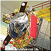
Rockot delivers second Geo-IK-2 satellite More than five years after the loss of the original Geo-IK-2 satellite, the Russian military made another attempt to jump-start its space-based geodesy. Developed at ISS Reshetnev in Zheleznogorsk, the second Geo-IK-2 satellite should provide very accurate measurements of the Earth's shape and its gravitational field, facilitating cartography among other military and civilian applications.
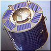
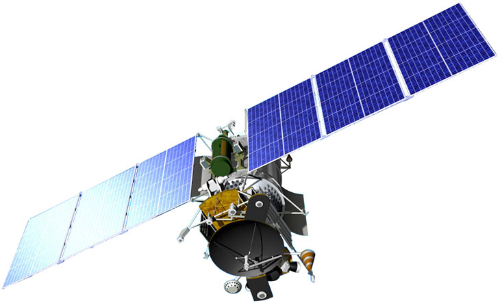
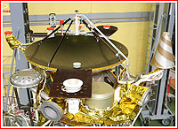
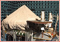
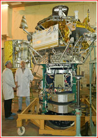
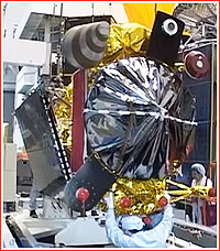
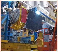
The circa 2015 depiction of the Geo-IK-2 (Musson-2; 14F31) satellite in deployed position in orbit sans thermal protection system. Credit: ISS Reshetnev
Geo-IK-2 No. 12 mission at a glance:
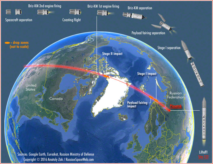
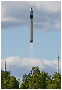
Mission history In June 2012, as the original Geo-IK-2 circled the Earth in a useless orbit after its botched launch 16 months earlier, the head of ISS Reshetnev told Russian media that the second spacecraft had been in company's storage, while the Ministry of Defense had been considering the decision for the development of the third spacecraft for the Geo-IK-2 network. By June 2013, the launch of the second satellite was promised in 2014, however all its electronic components were in the process of being upgraded to the "space" designation, which would certify that they could withstand the radiation environment in the Earth orbit, the head of ISS Reshetnev told Russian media. The launch date soon slipped to 2015 and in the spring of 2014, it was not expected before the end of 2015. As late as March 2015, the mission was still promised before the end of that year. By the middle of 2015, ISS Reshetnev announced that the Geo-IK-2 was undergoing testing at the company's facilities in Zheleznogorsk. In March 2016, ISS Reshetnev boasted that the second Geo-IK-2 had been manufactured despite an embargo on the supply of dual-use electronics, which the United States began tightening as early as the spring of 2013, as a result of worsening US-Russian relations. The company apparently was able to procure the required hardware in Europe, including the Sadko-3 altimeter (for the follow-on satellite), which was developed by the French division of the space consortium Thales Alenia, but likely used electronic components built in the US. The second Geo-IK-2 satellite arrived at Plesetsk at the end of March 2016 in preparation for launch in the following May. However before the middle of that month, the mission reportedly slipped to the beginning of June. The liftoff was ultimately set for June 4, 2016, at 17:00 Moscow Time (10:00 a.m. EDT). Geo-IK-2 No. 12 Launch profile The liftoff off a Rockot booster with a Briz-KM upper stage took place as scheduled on June 4, 2016, at 17:00 Moscow Time (14:00 GMT; 10:00 a.m. EDT) from Pad 3 at Site 133 in Plesetsk. The launch vehicle is carrying the Geo-IK-2 No. 12 geodetic satellite, also known by its military designation as Musson-2 and by its industrial designation as 14F31. According to the official Russian media, Lt. General Aleksandr Golovko, the Commander of the Space Forces within the Russian Air and Space Forces, oversaw the launch operations in Plesetsk and the Titov Chief Test Space Center began tracking the vehicle two minutes after its liftoff. The Russian military did not detail the flight profile for Geo-IK missions, but based on the known target orbit parameters and the information available from the original launch, some key aspects of the powered flight can be assumed. After a few seconds of a vertical ascent, the rocket headed northwest on a so-called retrograde trajectory, which took the vehicle westward, unlike most orbital missions which fly east with the rotation of the Earth. The ascent profile was designed to insert the satellite into an orbit with an inclination 99.4 degrees toward the Equator, extending from the North Pole to the South Pole of our planet. It enables remote-sensing satellites to observe the entire planet, as the globe makes a full rotation from west to east under the spacecraft's flight path every 24 hours. The first stage of the Rockot booster likely separated two minutes 16 seconds into the flight at an altitude of more than 68 kilometers in the upper atmosphere. Then, more than three minutes into the flight, the payload fairing protecting the satellite split into two halves and fell off at an altitude of more than 120 kilometers, safely beyond the dense atmosphere. Both, the first stage and the payload fairing, were to fall into the sea north of Norwegian Coast. The second stage continued firing until 5.3 minutes into the flight, followed by the separation of the Briz-KM upper stage along with its cargo at an altitude of around 240 kilometers. Still short of an orbital velocity, the second stage will reenter the atmosphere and fall into the Baffin Bay between Greenland and Canada. The official Russian media confirmed that the payload section had separated from the second stage of the launch vehicle at 17:06 Moscow Time (14:06 GMT, 10:06 a.m. EDT). The Briz-KM then fired its engine to insert the stack into an initial elliptical (egg-shaped) orbit over Arctic Canada.
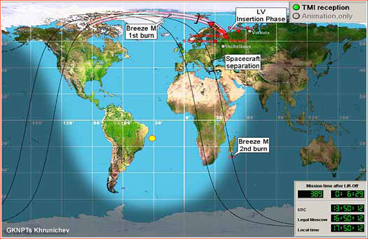
An approximate ascent scenario and a ground track of the Geo-IK-2 No. 12 mission. During this maneuver, the spacecraft left the range of Russian ground control stations and continued its mission according to its pre-programmed sequence. Upon completion of the first burn, Briz-KM entered an unpowered climb for slightly more than one hour, interrupted only be short bursts of attitude control thrusters to put the stack into the desirable attitude. When the vehicle reached the highest point (apogee) of its elliptical orbit over the Indian Ocean, Briz-KM fired its engine to make the orbit circular at an altitude of more than 1,000 kilometers above the Earth's surface. Minutes later, the space tug likely oriented itself for the separation of the satellite one hour 55 minutes after the liftoff at 18:55 Moscow Time (15:55 GMT, 11:55 a.m. EDT). By that time, Briz-KM and Geo-IK-2 re-entered communications range of Russian ground stations, as the two vehicles were making their second revolution around the Earth. As a result, ground controllers from the Russian military were apparently able to monitor this critical phase of the mission in near-real time. Due to the Earth's eastward rotation, the ground track of the second orbit shifted in the western direction, taking both vehicles from south to north across western part of Africa, the Mediterranean, Turkey, the Black Sea and Eastern Europe. As predicted, around 19:00 Moscow Time on June 4, the Russian Ministry of Defense had confirmed that the satellite was successfully inserted into its planned orbit. Around the time when Briz-KM was crossing the Baltic Sea, Scandinavia and then flew over the Arctic Ocean again, it likely began maneuvering itself into a "burial" orbit at a safe distance from its former cargo. By 19:05 Moscow Time on June 4, the Russian military confirmed that after several engine firings, the stage had entered a 640 by 950-kilometer orbit, well below the satellite. The Joint Space Operations Center, JSpOC, of the US Strategic Command, reported two objects associated with the launch (most likely the Geo-IK-2 No. 12L satellite and the Briz-KM upper stage after it had completed its maneuvers to enter a burial orbit) with the following orbital parameters:
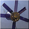
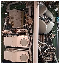
An approximate flight scenario of the Geo-IK-2 No. 12 mission during its first three orbits. Geo-IK-2 No. 12L prepares to enter service On July 7, 2016, ISS Reshetnev announced that in-orbit checks had indicated that all service systems of the Geo-IK-2 No. 12L satellite had been working without a hitch. At the time, specialists began a sequential activation of payloads on the satellite for testing purposes under flight conditions, the company said. Geo-IK-2 No. 12 satellite for KGK network The primary payload onboard all Geo-IK-2 satellites is the Sadko altimeter, which is named after a fictional traveler in a medieval Russian epic. The instrument is built by the French division of the consortium Thales Alenia Space and will be used to measure the distance from the satellite's orbit to the surface of the ocean with very high precision. As a result, the exact shape of our planet and its gravitational properties can be determined with a high degree of accuracy. The device was adapted from the Poseidon-2 altimeter, which was installed on the French Jason-1 satellite, launched in December 2006, and was designed for operation from an altitude of around 1,347 kilometers. According to some reports, the upgraded version of the altimeter developed for the second Geo-IK-2 satellite has a designation Sadko-2. Geo-IK-2 also carries a Doppler system, a time synchronizer, laser reflectors and a range finder. The satellite also features a sophisticated two-mode receiving and transmitting antenna developed at NPO PM. It was designed to maintain its geometric shape under the extreme conditions of space and, reportedly, is operating in the Ka-band. In addition, Geo-IK-2 No. 12L -- was also expected to carry a Miram microwave radio altimeter, which has been developed by a Russian company, RNII KP. The instrument promised to further improve the accuracy of geodetic measurements. (454) In the civilian sector, data from geodetic satellites can be applied to the study of tectonic plate movements, the monitoring of ocean tides and ice conditions, as well as help in measurements of the Earth's rotational velocity and in the determination of the exact position of the planet's poles. (455) At the same time, accurate knowledge of gravitational field properties along the flight route of ballistic missiles can help increase accuracy of their warheads. (99) No surprisingly, the Soviet and, later, Russian military funded the development of several geodetic satellites: Sfera, Musson, Geo-IK and Geo-IK-2. According to industry sources, ISS Reshetnev largely declassified Geo-IK-2 as a civilian project and even offered to include it in an international scientific effort known as Global Geodetic Observing System, GGOS, because the company needed to import many critical components for the satellite from abroad. According to ISS Reshetnev, the orbital constellation of Geo-IK-2 satellites should include two spacecraft circling the Earth in a near-polar orbit with an inclination 99.4 degrees toward the Equator and with an altitude of around 1,000 kilometers. However in April 2014, Counter-Admiral Sergei Kozlov, the Head of Military Topographic Directorate at the Chief of Staff, was quoted as saying that prospective Russian weaponry would need a new multi-tier Space Geodetic Complex or KGK, including two Geo-IK-2 satellites, two "gradient-measuring" satellites and two Blits laser-reflecting satellites. The ground segment of the KGK network includes stations in Shelkovo (East of Moscow); Sarapul (Udmurt Republic); Gelendzhik, (Krasnadar Region in Southern Russia) and the central geodetic data processing center in Moscow. Geo-IK satellites are launched on Rockot boosters from Site 133 in Plesetsk. Follow-on satellites In August 2012, ISS Reshetnev reported that Thales Alenia Space in France would supply the Sadko-3 altimeter for the Geo-IK-2 No. 3 satellite, intended to replace the original Geo-IK-2 spacecraft. According to the contract, the instrument was to be delivered to ISS Reshetnev at the end of 2014 or beginning of 2015. On Dec. 6, 2012, ISS Reshetnev announced that the company and its contractors had started the manufacturing of components for the satellite with a projected launch date in 2015 from Plesetsk Cosmodrome. From 2015 until around the spring of 2016, the launch of the third Geo-IK-2 satellite was expected in 2017. At the time, there were hints that the launch could be moved from Rockot to the new-generation Angara-1 rocket. After the two-satellite system is finally deployed and operational, it is expected to take from 2.5 to three years to accumulate a full set of data for the development of a global model of the Earth's shape. ISS Reshetnev's documents also indicated plans for the launch of the new-generation Geo-RG satellite in 2018.
Geo-IK-2 missions:
Read much more about the history of the Russian space program in a richly illustrated, large-format glossy edition:
|
|
|||||||||||||||||||||||||||||||||||||||||||||||||||||