|
Searching for details: The author of this page will appreciate comments, corrections and imagery related to the subject. Please contact Anatoly Zak.Related pages: 
|
| |
|||||||||
Yantar-1KFT (Kometa) In the 1960s, the very first photos of the Earth surface from orbit quickly proved their value to the military. In addition to tactical and strategic information found on images from space, visual data from orbit could be used to map the world without ever setting foot in a particular region. However, the science of cartography required elevation data on all pictured objects and accurate correlation of all images. To combine navigational and visual data, spacecraft designers developed specialized imaging systems and satellites dedicated to cartography.
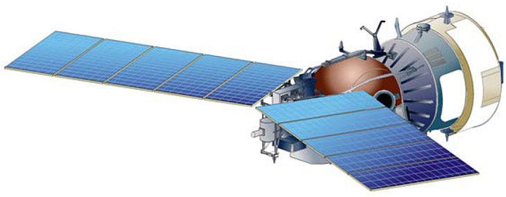
Above: Yantar-1KFT (Kometa). Credit: TsSKB Progress
Cartography from space In 1971, the USSR launched the Zenit-4MT satellite designed to test cartographic techniques. It was declared operational in 1976. Even earlier, in 1968, Branch 3 of OKB-1 design bureau in Kuibyshev (now RKTs Progress) had initiated the development of the Yantar-1KFT cartographic satellite. Architecturally, it was a hybrid of the propulsion module from the newly developed Yantar spy satellite and the descent module from the older Zenit and Vostok spacecraft. The Yahont-1 topographic camera was installed inside the ball-shaped capsule, however the larger the Topaz KVR-1000 panoramic high-resolution camera had to be attached to the exterior of the capsule. The satellite was also equipped with a pair of solar panels. The design of the Yantar-1KFT satellite was ready in 1975 and the first spacecraft was launched on Feb. 18, 1981, thus replacing Zenit-4MT. After seven launches, Yantar-1KFT was declared operational in July 1987. At least one such satellite was launched every year on Soyuz rockets until the dissolution of the USSR. By that time, the Yanatar-1KFT also became known as Kometa (comet). (623) The final Kometa flew in 2005. Pictures delivered by cartography satellites allowed the Military Topographic Division of the General Stuff at the Soviet Ministry of Defense to produce detailed maps of the Earth surface, including elevation data without conducting any measurements on the ground. As a result, practically any area of the Earth's surface could be mapped, including countries which were out of reach of the Soviet military, including its numerous adversaries in the Cold War.
Yantar-1KFT (Kometa) satellite developers:
Read much more about the history of the Russian space program in a richly illustrated, large-format glossy edition:
|
MEDIA ARCHIVE
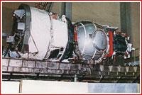
A Yantar-1KFT (Kometa) satellite in preparation for vacuum testing. Credit: TsSKB Progress |
|||||||||