|
Searching for details: The author of this page will appreciate comments, corrections and imagery related to the subject. Please contact Anatoly Zak.
Related pages: 
|
| |
|||||||||||||||||||||
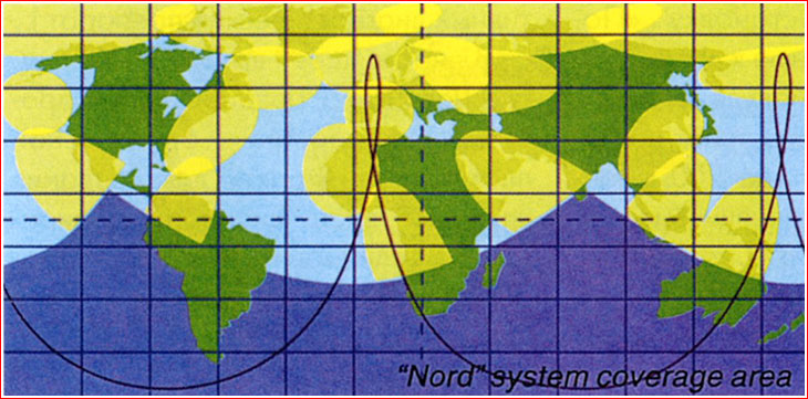
Nord: Connecting the north The Nord network was conceived to provide communications in northern regions of Russia and across the Arctic Ocean, which could not be effectively served by traditional satellites in equatorial orbits. The Nord satellites would be making each revolution around the Earth in 12 hours, rising over the horizon in the northern sky twice a day on opposite sides of the Earth.
Ground track and service coverage areas (yellow) of the Nord satellite. Credit: NPO Lavochkin
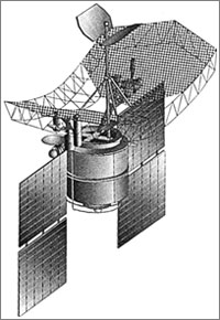
Exotic orbit Vast regions of Russia stretching along the Arctic Ocean are among the most remote and desolate areas in the world. Even global satellite communications, which emerged in the 20th century, barely covered these extreme latitudes. Moreover, the very top of the world, beyond the 81st latitude, was completely out of reach for satellites in the equatorial orbit. In the USSR, the Molniya satellites were designed to resolve the problem. The Molniya flew an elliptical path stretched and tilted over the northern hemisphere and thus gave their name to this type of orbit. The concept further evolved during the post-Soviet period in the Nord project. It appears that the Nord concept was a spinoff from an effort at NPO Lavochkin in 1990s to develop a new satellite system for early warning about missile attack. The orbital parameters chosen for the prospective early warning system would send the spacecraft 40,000 kilometers away from Earth over the northern hemisphere, followed by a quick swing over the southern half of the globe at a minimum altitude of 500 kilometers. The resulting 12-hour orbit, inclined 63 degrees toward the Equator, would keep the satellite over the horizon in the northern hemisphere for the most of the time, enabling its prolonged observation of "missile-dangerous" regions. At the same time, the planners also realized that similar orbits, as well as the satellite design and even some ground infrastructure could also be re-purposed for communications. NPO Lavochkin formulated the civilian application of the system within the Nord project. According to the company, the Nord satellites could be used for stationary and mobile communications, telephone and "inter-computer communications," (which soon became known as the Internet). In particular, the satellites could provide air-traffic control around the North Pole, relay data from weather and environmental control sensors scattered across the region and provide emergency communications. The company also saw the system being used for communications by farmers and natural resources industries in the northern regions of Russia, first of all, by oil and gas companies. The service coverage of the Nord system would roughly extend from 40 degrees North latitude and all the way up to the North Pole. According to NPO Lavochkin, stationary and mobile users would use 1,000-watt, 350-kilogram transponders with 10 beams. Stationary systems would have a bandwidth of 64 kilobits per second via 800 duplex channels and mobile systems could transmit 9.6 kilobits per second via 100 duplex channels. A description of the Nord project released in 1997 promised its use within the "integrated space system", later known as EKS. (207) NPO Lavochkin stressed that the Nord project was deeply rooted into existing designs and was based on serially produced hardware -- a clear reference to Oko early warning satellites. The company promised to develop the Nord system within two years at a price tag of $200 million. NPO Lavochkin also estimated that the same amount could be earned annually by a fully deployed Nord constellation, including four satellites. (118) The Nord project never materialized, but similar architecture of a satellite system was later used by Russian engineers at ISS Reshetnev and RKK Energia to develop Meridian and EKS (Tundra) constellations during 2000s. Known specifications of the Nord satellite:
Read much more about the history of the Russian space program in a richly illustrated, large-format glossy edition:
|
IMAGE ARCHIVE
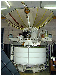
The original test version of the Oko early-warning spacecraft, possibly designated 5V95. Copyright © 2000 Anatoly Zak
Anatoly Chesnokov (1926 - 2016) a leading engineer on the Oko system at NPO Lavochkin, also proposed the Nord network. Credit: NPO Lavochkin
|
|||||||||||||||||||||