| |
|
|
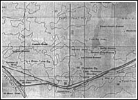
Secrecy around Tyuratam test range Although an army of people was involved in the early construction in the first ICBM missile range near Tyuratam, the Soviet security service were determined to maintain maximum secrecy around the project. Letters to soldiers and officers employed in the construction had to be addressed to Moscow-400, or Leningrad-300 and in their communications with friends and relatives personnel was strictly prohibited to give any details, which would hint about the location or the purpose of the site. In fact, even high-ranking construction managers in Tyuratam, have not been officially told what they were building, and they were instructed not to ask any questions beyond their direct responsibilities. In most cases the construction personnel had access only to the facilities they had directly been assigned to work on. (51) The US intelligence suspected the existence of a missile test site near Aral Sea around 1957. It became one of the major search targets of the U-2 spy planes flying over the USSR. The U-2 brought first aerial photos of the test range in August 1957. Using German military maps of the Soviet Union, CIA was able to correlate the area with the town of Tyuratam. A 1939 map showed a rail line branching out from Tyuratam junction and leading 28 kilometers in the steppe. More photos of Tyuratam facility, including a well known shot of R-7 launch pad, have been made in 1959. According to the NIIP-5 veteran, the Soviet intelligence knew about upcoming F.H. Powers' overflight in May 1960. (51 p. 160) In April 1960, an antiaircraft defense brigade was rushed from Leningrad to Tyuratam. The brigade's missiles arrived at the cargo terminal of Site 2 and were deployed at the facility No. 38 and near R-7's assembly building and were ordered to be in battle readiness by April 30. As F.H. Powers took off from the base in Pakistan on May 1, 1960, the NIIP-5 test range was put on high alert. According to a Russian source, (51 p. 161) Tyuratam air-defense crews activated their guidance radar too early, allowing the approaching U-2 pilot to detect the danger and bypass Tyuratam; the Western source, however, claims that cloud cover prevented Powers from flying over the site. (34) In any case, the plane was shot down later over Urals. After the U-2 fiasco, the US switched to the space-based reconnaissance. Also, electronic tracking stations set up along the borders with the Soviet Union, notably Tacksman 2 in northeastern Iran, would allow to monitor the launches until they disappear over Eastern Russia. Tacksman 2 was closed down in the wake of the 1979 Islamic revolution in Iran. (31 p. 31) The Soviets could do little to camouflage their activities in Tyuratam; nevertheless the center remained a top-secret site for decades. Today, hundreds of photos of the USSR, including those of its launch facilities made by the CIA's Corona spacecraft in the course of the Cold War have been declassified. Myth of Baikonur On April 12, a Vostok spacecraft with Major Yuri Gagarin onboard blasted off from Pad 1, opening the era of manned space flight. Along with enormous propaganda victory, Gagarin's mission brought a headache to Kremlin leaders. In order to register Vostok's flight as a world record with the International Aviation Federation, the USSR was required to name the launch site. Despite earlier U-2 flights over Tyuratam, identifying NIIP-5, a top-secret defense facility, was out of the question. The official policy developed over the years by the Soviet ideologists was not to confirm any unwelcome information on the Soviet affairs, no matter how widely known and well proven, if this information originated in the West. Instead, in the official telegram to the Federation, Aviation Sport Commission of the Central Aero-club of the USSR claimed that Vostok was launched from the "Cosmodrome" located near Baikonur. So, it was registered on July 18, 1961. (51) In the post-Soviet period, several Russian officials claimed the credit for choosing the village of Baikonur, as the "cover-up site" for the first manned space launch. Among them was Vladimir Barmin, the designer of the launch complex for the R-7 missile. The "real" town of Baikonur was located 250-300 kilometers northeast from Tyuratam and could be found on the Soviet maps of the period. According to various sources the name means in Kazakh either "the master with the light brown hair," (115) or "brown-rich" (the area was known to be rich in brownish copper, which was supposedly mined by GULAG prisoners as late as end of the Stalinist period). The town was picked as the origin of the Vostok mission because it was the first identifiable location downrange from the launch site. The Russian sources also said that in pre-revolutionary time, the artisan named Nikifor Nikitin was exiled to Baikonur for the "seditious talk about flight to the Moon!" Baikonur continued to be a place of exile in the Soviet time, when political prisoners, reportedly former army officers, worked copper and coal mines in the area. (51) In 1917, the mines of Baikonur were connected by a narrow-gauge rail line with the towns Karsakpai and Dzhezkazkan (future landing area for the Soviet manned spacecraft). Upon death of the Soviet dictator Joseph Stalin in 1953, the GULAG camps in Baikonur were abandoned. Ironically, the experiments with nuclear blasts in the upper atmosphere were reportedly launched from the area. Soon after Gagarin's mission, the name "Cosmodrome Baikonur" started appearing in the Soviet press. As time proved, such seemingly senseless deception would not fool many in the USSR and even less in the West. However, it did generate an awkward double identity for the biggest Russian space center. "Little Encyclopedia" of space flight published in the USSR in 1968, described Baikonur as "one of the biggest Cosmodromes of the USSR located in Karaganda Region." The 1985, the new and expanded edition of the Encyclopedia "placed" Baikonur into the Kzul-Orda Region. This is wrong for "original" Baikonur, but correct for Tyuratam! Old habits die hard A veil of secrecy started lifting from Tyuratam during the 1960s and 1970s, when a number of East-European and French officials, including President Charles De Gaulle, visited the site. Large-scale propaganda spectacles were staged at the test range to conceal its problems or hide details about its activities. Most of all, the Soviet authorities wanted to comuflage military nature of the "cosmodrome." During visits of NASA officials to the site in the eve of the Soyuz-Apollo docking mission in mid-1970s, all officers, who could be within reach of the US delegation were ordered to report to duty in civilian clothes. Civilian clothes were urgently issued even to rank-and-file soldiers, however, little could be done about their shaved heads! According to the veterans of the range, this type of "metamorphosis" was practiced in Tyuratam as late as 1988, during the preparation for the Phobos mission, which carried a wide array of foreign payloads toward Mars. (154) Page author: Anatoly Zak; Last update: October 2, 2018 All rights reserved
|
Copy of the German map circa 1939, showing Tyuratam area. Credit: Air Force magazine
Years after the end of the Cold War, the S-75 antiaircraft missile guards the entrance to the Baikonur museum, as a monument to its role in the air defense of the super-secret site in the early years. Copyright © 2001 by Anatoly Zak |